Wednesday, November 25, 2015

Namaste Nepal

As the saying goes, "All good things must come to an end." And so today I say Namaste to the beautiful country of Nepal and their amazing people. I've included a few pictures from my last walk around Kathmandu this morning.


Long ago, I had planned to give a further definition of the word Namaste, so it's only fitting that I include it as I depart.

Namaste is kind of like a praise to the person or people receiving the namaste. The word's meaning is “I bow to the divine in you" or "the spirit within me salutes the spirit within you." Namaste is a traditional Indian/Nepali greeting of respect and thank you, with spiritual and symbolic meaning. Namaste is usually spoken with a slight bow and hands pressed together, palms touching and fingers pointing upwards, thumbs close to the chest. It is used for both salutations (greetings) and valedictions (farewells).

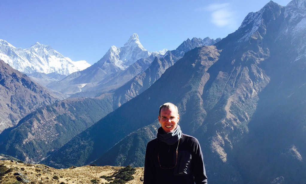
I will miss all the people who have made me feel so welcomed here.  I will miss trekking through the mighty himalayas, which I recently learned means "the land of snow".  I will miss the Dal bhat, even though I have had it for lunch and dinner almost everyday since I've been here!

Thank you, Nepal.  I promise to come back again someday.


- Posted using BlogPress from my iPhone

Tuesday, November 24, 2015

Last Days in Kathmandu

After completing my trekking, I've had a couple of days to spend wandering around Kathmandu and checking out some of the historic sites that I had not yet had time to venture to previously.

On Monday I went to Durbar Square. Here again, I've dipped into Lonely Planet to share some background on this historic site (the pictures are mine however and clearly show that many of the historic buildings were damaged in the earthquake and have temporary support structures to hold them up during repairs):


Kathmandu’s Durbar Square was where the city’s kings were once crowned and legitimised, and from where they ruled (‘durbar’ means palace). As such, the square remains the traditional heart of the old town and Kathmandu’s most spectacular legacy of traditional architecture.

It’s easy to spend hours wandering around the square and watching the world go by from the terraced platforms of the towering Maju Deval; it’s a wonderful way to get a feel for the city. Although most of the square dates from the 17th and 18th centuries (many of the original buildings are much older), a great deal of rebuilding happened after the great earthquake of 1934. The entire square was designated a Unesco World Heritage Site in 1979.

The Durbar Sq area is actually made up of three loosely linked squares. To the south is the open Basantapur Sq area, a former royal elephant stables that now houses souvenir stalls and off which runs Freak St. The main Durbar Sq area, with its popular watch-the-world-go-by temples, is to the west. Running northeast is a second part of Durbar Sq, which contains the entrance to the Hanuman Dhoka and an assortment of temples. From this open area Makhan Tole, at one time the main road in Kathmandu and still the most interesting street to walk down, continues northeast.


A good place to start an exploration of the square is with what may well be the oldest building in the valley, the unprepossessing Kasthamandap.

Read more: http://www.lonelyplanet.com/nepal/kathmandu/sights/historic/durbar-square#ixzz3sTB3mpFA

Yesterday, I went to Swayambhunath, also known as the Monkey Temple. Per Lonely Planet:


A journey up to the Buddhist temple and Unesco World Heritage Site of Swayambhunath is one of the definitive experiences of Kathmandu. Mobbed by monkeys and soaring above the city on a lofty hilltop, the ‘Monkey Temple’ is centred on a gleaming white stupa, topped by a gilded spire painted with the eyes of the Buddha. Depictions of these eyes appear all over the Kathmandu Valley.

Coming to Swayambhunath is an intoxicating experience, with ancient carvings jammed into every spare inch of space and the smell of incense and butter lamps hanging heavy in the air. The mystical atmosphere is heightened in the morning and evening by local devotees who make a ritual circumnavigation of the stupa, spinning the prayer wheels set into its base. It is a great place to watch the sun set over Kathmandu.


Read more: http://www.lonelyplanet.com/nepal/around-the-kathmandu-valley/swayambhunath/sights/religious/swayambhunath-temple#ixzz3sTDAUxDY

- Posted using BlogPress from my iPhone

Location:Jyatha,Kathmandu,Nepal

Friday, November 20, 2015

Trekking Sagarmatha National Park (Day 7-8)

On the seventh day, there was at last a hot shower after a long day of trekking (thankfully most of it downhill). The hike back to Namche covered the most ground of any up until this point, 12.2 miles, and still included one big ascent so that my iPhone registered another 129 flights for the day. It felt good to get down to a more breathable altitude of just 11,286' and to finally enjoy the luxury of a warm shower to wash away all that dirt and sweat.


After the shower, it was off the the bakery to treat myself to a chocolate croissant and some free wifi as I had not been connected for the past three days.


The next day was my final day of trekking on this trip as we returned from Namche back to Lukla. The total trek was 13.6 miles and added another 188 flights as we hiked down to 2610m before ascending back up to Lukla at 2840m.


For the 8 day trek, here are the total distance and flights climbed:

-66.8 miles (avg 8.3 miles per day)
-1127 flights (avg 142 per day)

It was a great eight days of trekking that I will never forget!

- Posted using BlogPress from my iPhone

Wednesday, November 18, 2015

Trekking Sagarmatha National Park (Day 5-6)

On the fifth day, my guide and porter and myself trekked to Dingboche. The hike would see us climb another 600m in altitude to reach 4410m/14468'. The oxygen level at this altitude is almost half of what it is at sea level (12% vs about 20.9%). We are now fully above the tree line and if it were not for the dry shrubs dotting the landscape it would feel like we were on another planet. The one nice thing about today's ascent is that even though we climbed the equivalent of another 114 flights over 7 miles is that is was mostly a nice gradual incline rather that steep ups and downs like the prior day's hike.


On the way up this morning, we spotted our first mountain goats (we would see more on the way down also). I should say my guide spotted the goats. I would have likely missed them without his keen eyes and ears. One of the challenges of trekking is you really have to always be looking where you are going and paying attention to the many hazards along the path. Those hazards can be as benign but unpleasant as stepping in fresh yak dung, to more serious risks like slipping on loose gravel on the steep inclines or descents, to twisting your ankle on the rocky and uneven trails, or the very real chance of stepping right off the edge of the trail to possibly dire consequences.


I was impressed by our lodge in Dingboche and especially liked the eco friendly way they used solar energy to boil their water.


Up until this point I'd been doing really well with little to no side effects from the high altitude beyond the insomnia (which as discussed was due to a number of factors). However, on this night I would experience the worst headache of my life. Fortunately, by morning, it had mostly subsided but by this point, I'd gone 5 nights with two hours or less of sleep and I couldn't see continuing that trend while risking more serious altitude sickness in an effort to reach Everest Base Camp at 5365m or just over 17,600'. My guide did convince me to try the acclimation climb up to Chhukung at 4730m/15518' which I was glad I did even though I felt a bit of nausea when we got there.


Afterwards we agreed to begin our descent down to Sangboche which was just under 4000m/13000' rather than spend another night in Dingboche and fortunately my headache largely did not return beyond a minor ache. While there is a small part of me that was disappointed not to have been able to continue on to Everest Base Camp, I feel like I made the right choice for my health and well being and truth be told, I was apprehensive about this trek from the time I signed up for it (due both to the extreme altitude as well as the duration of 11 days) and probably should have chosen a less intense trek from the beginning. None the less, I've truly enjoyed coming as far as I have, and seeing this amazing landscape even with the miserable nights.
Speaking of nights, I was actually able to get more sleep in Sangboche, that is until I was awoken at about 3:00 am by what at first sounded like someone walking on a gravel path outside my window. However, as I focused in more on the sound, I realized it was coming from within my room! It sounded like someone was going through my stuff, but it was pitch black and I couldn't see a thing. I tried to reach for my flashlight but couldn't find it (the thought occurred to me at this point that maybe my intruders had moved it), so I had no choice but to largely get out of bed and hit the light switch. Once the light was on I quickly scanned the room and saw no one. However, a moment later I heard some movement coming from one of my bags. I wasn't sure which one and then the rustling sound stopped for a moment. When the sound returned, I could finally tell it was coming from my backpack. Of course, I knew it was some sort of animal at this point, but the only way to find out for sure was to carefully open up my bag just enough to shine my flashlight inside and hope whatever it was didn't jump out at me. I opened the flap just enough to see a couple of mice trying to get into a half eaten pack of coconut crisps (cookies) that my guide had purchased for the three of us at Chhukung. This is a type of processed food I normally don't eat, so when my guide gave them to me I just had a few and then put them in my backpack. Leaving open packs of food in my pack is also something I normally don't do for obvious reasons. At any rate, I now had to figure out how to get rid of my uninvited guest. I grabbed my pack toward the bottom and turned it over and the mice and the coconut crisp package came tumbling out. The mice scurried away, but even after I put the crisp in a sealed ziplock bag, the mice kept coming back, so I left the light on for the rest of the night. I thought about just putting the crisps outside my door and letting the mice have at it, but decided I shouldn't feed or encourage them. So much for a good nights sleep.


- Posted using BlogPress from my iPhone

Monday, November 16, 2015

Trekking Sagarmatha National Park (Day 3-4)

On the third day of my trek, my guide, Bishnu and I did an acclimation climb in which we ascended a couple hundred meters and then descended back to where we started (in this case, back to Namche Bazar). We hiked to the Everest View Hotel which is at 3880m/12729'. As the name implies, we were able to get a glimpse of Mount Everest from here. However, due to the distance and size of other nearby mountains, Everest does not appear to be the tallest from this vantage point. In the picture below, Everest is taller of the two smaller more rounded peaks that are completely covered in snow.


The hike up involved climbing the equivalent of 100 flights of stairs and round trip we hiked just under 5 miles. On the steep descent back to Namche, I took this photo from above the village.


Up until this point, I've only talked about the trekking. Since most days only require 5-6 hours of hiking, that leaves plenty of time that needs to be filled. Most of the time I was able to find other Trekkers to talk to. Besides the Trekkers that I already mentioned, I met wonderful people from France, Sweden, Ireland, and South Africa among others. Also, when you are in Namche and some of the other larger villages, there are plenty of shops, bakeries and bars to hang out in, many of the later two offering free wifi so you can stay connected in this very remote and hard to access part of the world. All the lodges also contain a large dinning hall in which to eat or hang out in and read. One thing you don't do is spend time in your room which is often just a small box shaped space with a single bed or two that had no bathroom and is normally extremely cold due to the lack of any heating source and the drafty windows.


This brings me to what has been the most challenging part of this adventure.... nighttime. I knew from prior experience that sleeping in high altitude environments can cause insomnia, however, this was the first time that I've dealt with what I will call the quadruple whammy of high altitude, extreme cold (below zero), crappy thin foam mattresses (when they were new that might have been four inches, but after who knows how many months or years of use, they are more like 1-2 inches in the middle where it counts), and a super constrictive mummy style sleeping bag. For me, all these elements resulted in my getting 1-2 hours of sleep per night and lying awake rather uncomfortable the rest of the time. Now I should add that there are some factors that added to my discomfort that would not apply to others. One key factor is that I can't sleep on my back, so I sleep on my side. If you sleep on your back, you will likely fare much better than I did because your weight is more evenly distributed thus decreasing the need for a thicker mattress and the mummy style sleeping bags are best suited to sleep in this position. Also, because I was sleeping on my side most of my weight was born on my hip and shoulder. Thus, I needed to turn over frequently onto my other side once my shoulder or hip became sore due to the hard surface. This was very difficult to do in the mummy style sleeping bag. It's like trying to maneuver in a straight jacket. I literally would get short of breath just trying to turn over in the thin air. For all of these reasons I was dreading going to bed each night.


On the fourth day of trekking, we hiked to Debuche. We had actually planned to hike to Tengboche which has a large monastery but the lodges were all full, so we continued on for another 30 minutes. It was another beautiful day for trekking with clear blue skies and plenty of sunshine. We covered about 7.5 miles and climbed the equivalent of 186 flights during this up and down day of hiking (we probably descended at least 140 flights).

- Posted using BlogPress from my iPhone

Saturday, November 14, 2015

Trekking Sagarmatha National Park (Day 1-2)

To begin my trek, I flew with my guide, Bishnu, from Kathmandu to Lukla, Nepal. Just like flying to Pokhara, the flight was very short, only 25 minutes long, and provided a great view of the Himalayas. Lukla's airport is said to be the most dangerous airport in the world, and you can see why as it is tucked into the mountains at 2840m/9317' and the runway is not only very short but ends very abruptly against the side of the mountain (which has a nice Welcome to Lukla sign on it). It kind of feels like landing on an aircraft carrier that's perched at about a 35 degree tilt on the edge of the mountain. Below is the view as we approached the landing strip.


After landing safely, we gathered our gear and Bishnu hired a porter and we headed to a lodge called the Nest for some breakfast. Here I met some other Trekkers from Canada and England and we talked about our upcoming adventure.


Afterwards, we began our trek with a moderate hike that brought us to the village of Phakding (elevation 2610m/8562'). Along the way, we passed through several small villages, many of which had Buddhist stupas, prayer wheels and prayer flags. We passed by many porters and yaks carrying tremendous loads on their backs as much of the food, drink and even building supplies are carried up. We covered roughly 7 miles and even though it was mostly downhill, there was plenty of up and down, so I still managed to hike up the equivalent of 60 flights of stairs. At lunch, I met a father and son from Australia who were on their way down from Everest Base Camp. They told me they had prepared for the thin air by working out on treadmills at a facility in Sydney that simulated the decreased oxygen levels at high altitude. These facilities are often used by professional athletes to enable them to build up more red blood cells. I'm guessing it wasn't cheap, but certainly a good idea if you have access to such a facility.
After spending the night in Phakding, we began our second day of trekking to the village of Namche Bazar, which would be much more challenging, as we would ascend from 2610m to 3440m/11286'. The hike was about 8 miles long, but involved going up the equivalent of 260 flights of steps (and crossing numerous suspension bridges like the one in the photo below). While not quite as many flights as my trek to Kokona two weeks ago, this trek was at a much higher altitude and proved to be a very challenging climb. I was pretty physically spent by the time we checked into our lodge for lunch after the 5 hour trek. This picture shows the beginning of our big ascent.


Namche is the gateway for all Trekkers in Sagarmatha National Park, regardless of whether they are going to Everest Base Camp, Gokyo Lake or doing some other circuit. It's also the gateway for climbers looking to ascend Everest or any of the other 8000m+ peaks in the park. Currently there are no climbers heading to Everest because the month of May is the only time of year that the weather is suitable to attempt the summit.
- Posted using BlogPress from my iPhone

Thursday, November 12, 2015

Farewell Chanaute!

In the blink of an eye, my two months of volunteering in Chanaute has come to an end. I'll never forget the people and the experience of living in this remote village of Nepal. From the bewildered looks on the faces of Mina and Bina, the clinic midwives, on that cloudy afternoon in September when I arrived with two giant suitcases in tow and not speaking barely a word of Nepali (beyond Namaste!), to the fond farewells that have taken place over the past few days, it's been a wonderful experience.


I will miss Mina, Bina and Copola who run this clinic seven days a week and without whom I could never have treated all the patients who have come for acupuncture. I will miss the warm smiles and friendly "Namastes" of the people who I have treated over these past two months as well as the invitations to join them for tea or dinner in their homes.


I will also miss the hikes along the endless trails through the serene mountains and the natural beauty of this village tucked along the Melamchi River. I will miss the sheer enthusiasm that comes beaming forth nearly every time I say "Nameste" as I meet or pass by the children of Chanaute and the nearby villages. And finally, I will miss the young friends I have made and who I have posted about several times before: Saugut, Rakesh, Suman and Karki.

A few days prior to the day I was to depart, everyone agreed that it would be best if I left on the 6:15 am bus to ensure I was able to get a seat for the four hour return trip to Kathmandu (especially because it was during the holidays and many people would be trying to go visit relatives). I assumed that any good byes would take place the day prior since I'd be leaving so early. At least, that is what we would normally do in America. So I was very surprised to awake at 5:30 am and discover over a dozen people came out to give me a warm send off with tika, maalais (flower garlands) and khadas (ceremonial scarves) and then walk with me to the bus stop. It's just another example of the loving kindness of the people of Chanaute that I will never forget.


- Posted using BlogPress from my iPhone

Location:Nepal